Blog TWHS Visits
WHC 2023: Kuldīga
I am generally happy to spend the summer months of July and August at home, but I always plan a mini-break in Europe halfway through just to not get bored. So in April I took my chances and booked a 4D/3N trip for early August to Latvia and Denmark to check out two upcoming nominations: Kuldiga and Trelleborg. It turned out that I had a lucky hand in choosing these two, as they both got positive recommendations from ICOMOS and will almost surely be inscribed in September 2023. As Kuldiga is the lesser-known of the two, I will focus my report on that Latvian town.
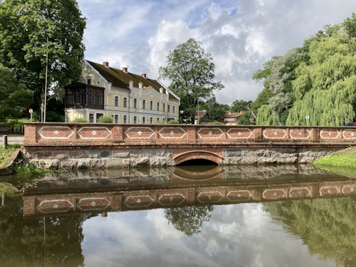
Although I’d wanted to go there from Riga by public transport, there are no direct buses and connections seem infrequent. So I rented a car from the airport and drove there easily in 1.5 hours. Kuldiga lies deep in the countryside, and it certainly looks like you’re arriving at something important. One enters town via the large new stone bridge (a one-way street), and there is even a parking lot for tour buses. The streets were also filled with parked cars – this is really a popular destination for Latvian daytrippers.
Kuldiga (named Goldingen at the time) is strongly linked to the peculiar history of the ministate of the Duchy of Courland. Although their home base in Europe was tiny, they managed to establish colonies in Gambia and Tobago. That all happened in the 17th century, but unfortunately, there are few tangible links with today’s town. Its older buildings mostly date from the 19th century. The setting of the town, along a river and next to a ‘waterfall’ (more like rapids), is its main strength. The shape of the town has been unchanged for centuries.
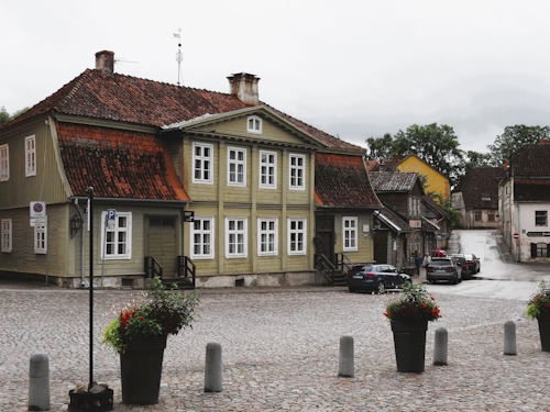
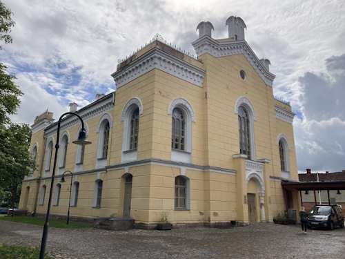
I saw no banners or other adverts to announce the WH nomination (they’re obviously more modest than Schwerin). The only thing geared at international tourists seems to be the new direction signs, which are both in Latvian and English. There’s little interpretation of the sights: some buildings have an enigmatic name shield like “Dwelling House” and the former Synagogue (now a Library, photo 3) isn’t signposted at all. Most buildings aren’t in great shape and it is unclear what their use is nowadays.
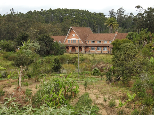
The signs post to places all over town, but only a part of it lies in the core zone: the area on a hill near the waterfall plus the streets with historic houses leading towards the Old Town Hall. As I am writing this only half a day after my visit, I find it hard to name any sight that stayed with me. There are a few timber-framed buildings, there's the much-photographed view from Pasta Street #5 towards the oldest wooden building in town next to a canal and there is a large Lutheran cathedral. My favourite building was the former District Court (photo 1).
Kuldiga’s Nomination Dossier does its utmost to link the unique Courland history with what can be seen on the ground. They’ve put in so much effort that after reading it I felt it would get the sympathy vote. But to me, it still feels like a small town jumping on the tourism bandwagon - and maybe rightly so as there probably isn't anything comparable in the west of Latvia. ICOMOS in its evaluation dismisses most of Kuldiga’s claims, didn’t find the Courland history too relevant and Kuldiga even wasn’t the economically and politically most prominent town in Courland anyway. But there’s a plot twist of a magnitude I can’t remember ever having seen from ICOMOS before – hey, why won't we inscribe it on different grounds? It is a historic town with multiple layers from the 13th to the early 20th centuries. And then we swap the proposed criterion 3 for 5. During the process, the Latvians even changed the boundaries of the nominated property on the advice of ICOMOS and also altered this in the Latvian legislation. Oh, and of course we will rename the site as well to “Old Town of Kuldiga”….
Els - 6 August 2023
Comments
Nan 6 August 2023
Weird prcoess by ICOMOS to rewrite on the fly. But probably they figured better to put OUV right before a site gets inscribed on wrong criteria via political machinations.
Generally, a historical town(scape) in Eastern Europe / Baltics feels like it's okay to be added as rewritten by ICOMOS: And happy to get a reason to go back to Lativa/Riga for an extended weekend.
Blog Books
Book: Natural Wonders of the World
I generally enjoy ‘Wonders of the World’-kind of coffee table books, especially when a lot of thought has gone into the selection of the cultural or natural sights presented. I recently bought a somewhat older one, published in 2017: Natural Wonders of the World. It was published by DK, also known for its glossy travel guides. Does it bring any value to WH enthusiasts?
What is it about
The hardcover edition of over 400 pages is too heavy to hold in your hands, so it is a ‘table book’ indeed. Ordered by continent, it shows and explains subjects such as geology, rivers and lakes, deserts, etc. The book starts with how the Earth was formed, and then for each continent, it details how that continent was shaped. There are deep dives into specific topics such as plate tectonics and karst landscapes as well. It ends with an extensive glossary of all the terms that will help you to understand an IUCN evaluation better.
The book is meant for browsing instead of reading from A-Z: it reminded me of what an Encylopedia looked like before the emergence of Wikipedia.
‘Missing’ WHS material
Although places that are already on the WH List or on one of the Tentative Lists are dominant among the examples, I noted down a few additional ones:
- San Andreas Fault (USA): one of the best examples of a transform boundary fault in plate tectonics, with one plate moving over another.
- Cave of Crystals (Mexico): caves that contain some of the largest natural crystals ever found.
- Bryce Canyon (USA): an eroded landscape of scenic beauty that developed in an ancient lake.
- El Tatio Geyser Fields (Chile): largest geyser field in the Southern Hemisphere.
- Quelccaya Icecap (Peru): the second-largest glaciated area in the tropics.
- General Carrera Lake (Argentina, Chile): a deep lake with unusual marble geological formations.
- Biebrza Marshes (Poland): wetland that is one of the largest wildlife refuges in Europe.
- Deccan Traps (India): one of the largest shield volcanoes.
- Hyden Rock (Australia): one of the oldest rock formations in Australia, picturesquely shaped like a tall breaking ocean wave.
The book also has a chapter on Extreme Weather – an interesting addition as well I think, but it would be hard to pin down these events to specific places.
Pros and cons of the book
The photography is excellent, and the text goes beyond the clichés as well. I especially enjoyed the ‘deep dives’, where for example the internal structure of the earth and "what’s inside Belize’s Great Blue Hole" are explained by illustrations and explanations of the applicable terms.
The biggest con I see is that, although the book was originally published in the UK, it focuses too much on examples from the USA – the North American continent is allowed by far the most pages and even then Mexico and Canada are hardly mentioned. Overall, it just has a tad too much on the well-known examples where great photos were available – the eroded landscape of the Ennedi is missing for example and the much smaller Meteor Crater is chosen over Vredefort Dome. Also, little or no space is given to fossil forming, while glaciers take up many pages.
Overall I'd conclude that it is a pretty book to receive or give as a present.
Els - 30 July 2023
Comments
Kyle Magnuson 30 July 2023
The best location (in my opinion) to see the San Andreas Fault is Carrizo Plain National Monument.
Blog WHS website
The WHS Commandments pt.2
So here’s the long-awaited follow-up to the Commandments: the set of best practices regarding visitor management that a WHS should adhere to in order to accommodate a WH traveller. I’ve tried to incorporate your comments as much as possible. There could have been 9 or 11 commandments, but I couldn’t help to steer towards 10!
The final Ten Commandments
- You show your OUV! You do not keep it to yourself (looking at you, people of Stoclet!). You may restrict visitor numbers when overcrowding becomes a concern, but access should be allowed via a mechanism that is open to everyone. Keep seasonal closures to a minimum and make sure the opening hours are generous.
- Thou shalt be ready to receive visitors after becoming a WHS Be on your best when you reach WH status. Be prepared for a surge in visitors. Offer them free entrance or another freebie in the first weeks to celebrate with you. Make sure that all maintenance, accessibility are renovation issues are resolved. Don't be like the Margravial Opera House which stayed open for only 3 months and then closed for 6 years! Or like Saudi Arabia's Turaif Quarter which continued renovations until 13 years after the inscription it finally opened.
- You are clear about your core zone You deliver a good quality, digital map to the WHC Bureau desk. Also, on-site, you make clear which areas of your property are protected as part of the WHS.
- You shall have a proper UNESCO plaque This is already a requirement in the guidelines from UNESCO. Display it proudly in a freely accessible area. Let a local artist make an interesting design. The plaque should also state in which year you reached WH status and for what reason, to educate visitors without prior knowledge about WHS.
- Thou shalt practice fair pricing Entrance fees should be appropriate to the value of the site and the time to be spent there. Also stay away from foreigner pricing, especially with the rapid growth of the middle class in formerly "poor" countries.
- You shall create and maintain an official website On the website, you show your opening hours, entrance fees, and any special visiting conditions if applicable.
- Thou shalt not unduly limit or charge fees for personal photography Photography for personal use should be granted and at no extra cost, except for limited cases where the use of flash could genuinely damage the OUV of light-sensitive decoration (cave art mostly), or bringing cameras cause some form of danger.
- You shall spend some money on proper paper tickets Provide the visitor with a ticket that can be kept as a souvenir. A pretty ticket, preferably DIN A6 or smaller, carton board, clearly stating the location and time of visit. So no more thermo prints and no generic Indian archeology tickets.
- Thou shall provide translations When you only allow visits via a tour, provide printed and plasticized translations of the texts in a number of languages (done via Google Translate should be good enough). So no more waiting for the only tour in language "X" of the day or having to follow around without any/much understanding. When the interpretation of your site relies heavily on information panels, provide texts at least in English in addition to your native language(s).
- Thou shalt not force visitors into packages or tours Always try to open up a part of a site to be explored independently (where that is feasible of course), so people do not have to wait for a tour to start, or have the stress of needing a reservation or having to be in large groups which limit the enjoyment. Consider using audio guides, or ‘stationary’ guides that explain (and keep watch on) the essential elements of a route.
This list now also has a permanent spot on the website and is accessible from the main menu via the Community dropdown.

Awarding the badge
So now the time has come to put the, from a visitor's perspective, excellent sites into the spotlight. My proposal for the follow-up process is as follows:
- To earn THE badge, a site should comply with commandments 1-7, and score decent on 8-10 as well. A rating system 1-10 for all WHS would be too cumbersome I think, as the evaluation will be quite subjective anyway and we want to put the focus on the stellar sites. Also, many sites don’t have full data or aren’t visited that often.
- I think you’re best qualified to propose a site for a badge if you have (recently) visited it. So you can propose only such sites. And you must be clear in your explanations. Be an advocate for the site.
- The other community members are the judges. They can ask critical questions about the proposal. At least one supporter that has also visited the site is needed to award the badge.
Any suggestions about the process? I’ve started a trial post focusing on my proposal, Gunung Mulu.
Els - 23 July 2023
Comments
Els Slots 23 July 2023
Actually mostly because commenters did not find it necessary: "serial sites: would be solved by a good map (#3) and a decent official website (#6) already -> propose to delete". Also, it would not be applicable anyway to most of the sites, as only a minority are serial sites.
Jay T 23 July 2023
Thanks for the updated list, Els! The only previous commandment I notice significantly by its absence would be the one regarding the serial site. Was the rationale because it may be too difficult for serial sites to comply with?
Blog WH Travellers
The Value of a TWHS
The late, great WH traveller Iain Jackson was known for his specific ‘rules’ regarding the process of visiting and counting WHS. For example only counting a serial site as visited when having seen 50% +1 of its locations, or only ‘ticking’ sites after they have been inscribed. Most of us thought at the time that he had very high moral standards. But he also was very efficient, especially regarding the time spent towards sites on the Tentative Lists (TWHS): none. More and more I now notice that completing countries’ T Lists has become a goal in itself, with Nomadmania even adding WHS and TWHS into one total number, thereby implying that they are worth the same. Personally, I think TWHS should only sparsely be added to travel itineraries, and here is Why:
The ones already on the WH List are better
They’re better because
- of the process they have gone through: they’ve been prioritized by their country, have a full nomination dossier and a management plan written for them (against great cost and lots of stakeholder negotiation), have been vetted by IUCN/ICOMOS, and have been confirmed by the WHC.
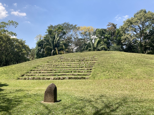
- the top picks were put forward and included first. Looking for example at the Khmer and Maya sites, Angkor was included in 1992 and Tikal in 1979, Copan in 1980 and Chichen Itza in 1988. For the combined 2022/2023 session, we will be looking at Koh Ker and Tak'alik Ab'aj (photo 1) – two minor sites within the history of these empires that may hold some scholarly interest but are a far cry from outstanding.
- they gain higher praise from our community: while 89% of the current rated WHS get a rating of 2.5 stars ('average') or higher, only 71% of the rated TWHS are recommended to be inscribed by more than 50% of the voters.
Of course, the T Lists do contain some that are equal to or even better than similar, lower-rated sites that are already inscribed, or are just worthwhile to visit because they cover a particular niche that you may enjoy. But the overall average quality of the set is worse.
The success rate of an average TWHS is only 14%
From a quantitative perspective too, it makes no sense to spend time and money at random TWHS. Looking at the past 10 years (I have taken the period 2012-2021 as there was no session in 2022), 239 TWHS became included in a WHS. 145 have been removed from the T Lists in the same period. In comparison with the 1726 TWHS still left at the end of 2021, this means a success rate of just below 14% across 10 years.
The number of new TWHS grows faster than the number of new WHS
The success rate will not double to 28% across 20 years because of the high refresh rate of the TWHS. There were 667 new TWHS over the last 10 years, while only 222 got inscribed. The combined Tentative Lists have grown from 1325 in 2006 (when the first database became available on the UNESCO website) to 1780 entries at the moment of writing, while the WH List grew from 827 to 1157.

And it is not only the growth that is worrisome: the lists are highly variable as well. The Operational Guidelines of the WH Convention advise countries to reevaluate their T Lists at least every 10 years. So you can have visited all Bangladeshi TWHS and the next week they unexpectedly publicize a fully revamped list.
The T Lists have strayed from their intended purpose
Although, according to the Operational Guidelines, a Tentative List only exists to identify "those sites which they consider to be of potential Outstanding Universal Value and which they intend to nominate during the following years", the practical reality is that some countries see this much broader. And there is no one stopping them: a country can submit any Tentative List, and there is no check of its contents. That’s why we also see so many TWHS lingering there without explanation for OUV, or without geographic coordinates, or of sites that have already been inscribed. This results in some countries having very long T Lists: the Turkish one would take 85 years to deplete even if they had a successful nomination every year. As I said in my review of the Turkish ones: it looks like they have brainstormed but forgot to cluster and prioritize. These unrealistically long T Lists seem to serve mostly a domestic purpose: getting on a Tentative List is already a prize for some local or regional authority within a large country.
My personal approach nowadays is: only take in TWHS that (a) are likely to be nominated in the next 2 or 3 years, (b) sound particularly interesting, or (c) will expose me to a wholly different part of a country that I am visiting (such as El Imposible in El Salvador). But you might as well use any other resource (AtlasObscura, old-fashioned guidebooks, Aspiring TWHS etc.) for the latter two reasons. What's your take on 'ticking' TWHS?
Els - 16 July 2023
Comments
Durian 22 July 2023
Another issue of TWHS is that it is an easy loophole for corruption on local governmental budget especially what I observed in Southeast Asia or even in Japan. Having local site in TWHS will create a rightful reason to set a budget to promote or to prepare nomination without proper outcome and that money go to certain academics and local construction businesses who have connection with local politicians.
Els Slots 21 July 2023
And another 'rule of thumb' that became clear to me after browsing through the 2023 nominations: be careful with upcoming whs where the coordinates are not clear from the twhs documentation and require a (costly) detour.
Clyde 21 July 2023
I adopt a very similar approach too, but I also put in extra effort if it is in an area without many whs and of interest to me, since the chances of returning only for that extra tick would be close to zero.
Els Slots 17 July 2023
Quoting Nan Unesco should enforce a regular cleanup. If a site makes no visible progress for a decade, it should be removed from the tentative list.. Really good idea. Or order that a T List may only include 10 sites at any time. The sheer numbers make it unmanageable. The 1780 sites today would take over 50 years to get all inscribed (on an average of 35 a year and even disregarding the limit of 1 per year per country).
Nan 17 July 2023
One more point to mention. The late Iain's argument was not just rule based, but also on practical efficiency.
If you spend time and money on getting to a potential tentative site with x% probability of being inscribed, this may not be the best use of your time and money overall.
A few more observations:
* It would already help if Unesco enforced minimum documentation standards before adding sites to the tentative lists. I think there needs to be some gatekeeping between aspiring and tentative.
* It's not just Turkey referencing Unesco pre inscription. Schwerin, Germany, does, too. They have signs saying "2015 - Submitted to the tentative Unesco world heritage list" or sth in town.
* Unesco should enforce a regular cleanup. If a site makes no visible progress for a decade, it should be removed from the tentative list.
* Wondering about my in vain count... It's not that many actually :)
Meltwaterfalls 16 July 2023
I think Nan has covered my main approach. I will visit if they are easy to pick up e.g. already on my route, have a component in a city I am already visiting.
If they are scheduled for the next couple of years I will try visit. I learned the hard way with Naumberg that a negative evaluation doesn’t mean it is a dead proposition, especially in a tenacious Western European country.
And then there are some that I am interested in anyway, and the fact they are TWHS is just a bonus to a visit I was already going to make. Some that come to mind are Pamphula, Scrovegni Chapel, works by renowned C20/21 architects
Dare I say it but as with WHS themselves, these sites are a framework to build travelling around for me, not necessarily the purpose of travel itself. (Though I will admit the thrill of a tick will mostly drive me to places I would never contemplate in other circumstances)
Nan 16 July 2023
I think hunting for tentatives is a bit of a fools errant. Even with scheduled sites, the countries may change their priorities fairly late in the game, so a lot of effort is in vain.
I remember going to the Prosecco Hills 9 months before inscription. I had studied the nomination, identified key structures and went. Then the WHC cut it down and I barely made it into the greatly reduced core zone.
Last year I went to the cold deserts of Uzbekistan, but the locations were off, the description incomplete... I am not sure that the location I visited will count and I spent serious money on a 4wd plus driver.
So, how do I go about tentative sites:
* I dont go out of my way to see sites I dont care about. If i can squeeze it in along the way or need sth to do for a buffer day, it's fine.
* Scheduled tentatives are prioritised, especially if a revisit of the area is unlikely. Reason is that the success rate of scheduled tentatives unlike general tentatives is rather high.
* I make a bit more of an effort for unreviewed tentative sites.
Some practical points:
* Logistics for tentatives is often harder as they dont feature on the tourist itinerary yet.
* Without map and OUV statement it's often harder to appreciate the more exotic sites.
* Turkey uses their tentative sites for claiming, incorrectly, that these sites are unesco.
Els Slots 16 July 2023
Thanks for the clarifications regarding Nomadmania, Thomas. Hope it stays limited.
Thomas Buechler 16 July 2023
A great evaluation, Els.
Myself, I mainly visit the sites on the Tentative List, if:
a)they are nearby of my itinerary where I go anyway
b)they are proposed for inscription in the years to come
c)of great value or interest to me
d)I am with someone who wants to visit them
Nomadmania by the way does have separate lists and rankings for both UNESCO and Tentative Sites, and only combines the two in the category of 'Wonders'. On the people's individual profile the Tentative Sites don't even appear, also they are not counting in the people's ranking for TBT-biggest travelers.
Blog Countries
Top Tips for Madagascar
In June, I spent 23 days travelling around Madagascar. I saw all 3 WHS and 2 of the TWHS. I really enjoyed this unique country with its calm and friendly people, who together with the good accommodation and food options soften the impact of travelling in a country with a GDP lower than Chad, the DRC and Haiti. Herewith are some tips for travelling to Madagascar as a WH Traveller.
1. Tick the WHS and you get a balanced itinerary
There are few countries where the WHS cover the essence so well, and in a relatively low number of sites (3). Madagascar’s ecoregions are divided between the wet East and the dry West – each has a natural WHS. And Ambohimanga is the most important cultural-historic site on the island. I see future potential mostly outside of the current T List: a cultural landscape featuring the carved wooden houses of the Zafimaniry ethnic group, or one centered around the vanilla production. Antsirabe and Andasibe (Photo 3) have wonderful French-colonial railway stations. Or natural sites such as the dramatic Cirque Rouge or the bird-friendly Ankarafantsika NP. I surely would support more cultural WHS as it would diversify travel and avoid for Madagascar to become a 'safari country' where wealthy tourists stay in isolated luxury resorts while the local population cannot profit.
2. Don't plan too tightly
To see the 3 WHS you realistically need 2 weeks. If you want to see more, have some beach time, or view different lemur species, it is better to allocate 3 weeks. But even then you will only have covered part of the country. Madagascar does slowly wear you down because of the time-consuming and tiring transport and the hygienic circumstances in the public space, so plan plenty of rest days as well.
3. Don't overpay for tours
As it is not possible to do the 3 WHS only by public transport (especially Tsingy isn’t), you will have to at least hire someone for part of your stay in Madagascar. Around Antananarivo, you can get away with using only public transport.
Organized tours from abroad are eyewatering expensive, especially from UK/US providers (Dutch companies are able to do it on a shoestring and I encountered one of their large groups even crossing the Tsiribihina River towards Tsingy). If you cut out the middle man and go directly to the more reputed Malagasy providers, they still do not hesitate to quote up to 400 EUR a day for a private car+driver and hotel. This while the best 3 star hotels only cost around 30 EUR a night and the average Malagasy earns only 50 EUR a month.
The main cost drivers are transport and the risk involving that transport (delays due to blocked roads or ferries not running, cars breaking down, cancelled flights). The transport of choice is the 4WD, although it really isn’t necessary everywhere (the main roads in the Central Highlands can be done without). Those 4WDs are expensive to purchase, maintain and run, and are in the hands of the happy few of rich Malagasy who enjoy this demand.
So the trick is to scout around for smaller Malagasy entrepreneurs who can still deliver safely. I worked with two of them, at a cost of 150-200 EUR a day. While comparing offers, do look closely at what is included: some quotes are without fuel (which is as expensive in Madagascar as anywhere in the world), and others even include park and local guide fees (which can add up). Be aware that those smaller companies will not be able to cover high unexpected costs such as a new flight ticket, so if you’re particularly risk averse (actually: enjoy blaming someone else when a risk materializes) go for one of the overpriced foreign tour operators with whom you can argue after your trip. But if you are risk averse, Madagascar isn’t for you anyway.
4. Go and see those lemurs
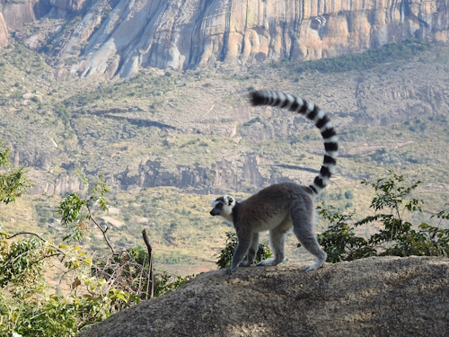
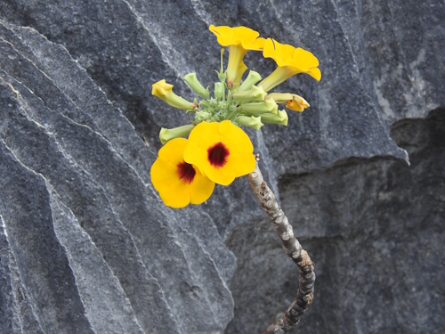
Madagascar is a top favourite among mammalwatchers as it contains no less than 108 lemur species (and a few other mammals as well). Every national park or nature reserve seems to have its own species, which provides variety and easy ticking. The species differ quite a bit from each other – from the playful ringtailed lemurs living in large groups to the majestic indri moving around only with their own nuclear family. Compared to their closest relatives, the monkeys, I found the lemurs calmer and less exciting in behaviour. Some species have incredibly cute teddy bear-like faces (Great Bamboo Lemur), others sport the ears of Mickey Mouse (Indri) or can jump powerfully using their hindlegs (Sifaka). As only small patches of forest remain in Madagascar, all lemur species are endangered - this was my first time seeing so many of even critically endangered species.
Lemurs inhabit both Malagasy natural WHS, but I’d recommend seeing some more at the lovely Anja Community Reserve (great setting, see Photo 2) and at Andasibe where there are effectively 4 parks/reserves that you can visit, with good views of Indri and Diademed Sifaka for example. Madagascar also has no shortage of ‘lemur parks’, rescue centers, and roadside attractions featuring tame or captured animals, but these should not be endorsed.
Els - 9 July 2023
Comments
Dennis N. 13 July 2023
Thanks for the Madagascar summary and earlier reviews. I had a trip booked in 2020 with the usual results for that year, but I haven't fit rescheduling it into my plans. It's interesting to see your mostly independent tour as I had resigned myself to a decent packaged tour that I had found.
Els Slots 10 July 2023
As far as I am aware, there are only small numbers of them left in the area around the Avenue of the Baobabs. I found the latter a bit of a tourist trap - fully natural and picturesque of course, but I don't see a 'higher' global value.
Jay T 9 July 2023
Great tips! I’ve enjoyed reading your reviews of Madagascar. In regard to potential future sites for Madagascar, what were your thoughts regarding a natural site protecting the baobab (the giant baobab in particular)?
Blog WHS Visits
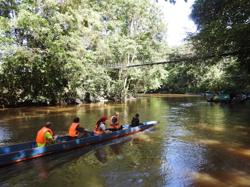
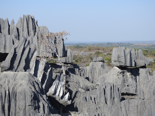
WHS #846: Tsingy de Bemaraha
Although it has decent tourist facilities, the Tsingy de Bemaraha is only for the hardened traveller as realistically there is no easy way to reach this park on the west coast of Madagascar. The property is so poorly accessible from the nearest city or commercial airport that it almost fits into our ‘Takes more than 5 days’-connection: a return trip takes at least 5 days from Tana. To make matters worse, it nowadays should be visited as part of an armed convoy due to safety concerns as there have been robberies along the route. There is no public transport to the site, all has to be done by 4WD, although the very wealthy could charter a bush plane and land on an airstrip that lies some 8km from Grand Tsingy.
The road to Tsingy from the coastal city of Morondava (195km/8h) starts with a passage through the well-known Avenue of the Baobabs. From that point on, the sand road is all there is – Tsingy for that reason also is inaccessible during the rainy season. A bit further on lies the turn-off for Kirindy Forest, a park that has severely deteriorated since Covid: people abandoned the place, the dogs entered, and the resident fossa left after it found not enough food. The next bit of excitement comes after 4 hours at the crossing of the Tsribihina River near Belo: it takes about half an hour by a simple ferry that can take four 4WDs. Lunch is had in Belo, which has a couple of good restaurants. From Belo, the armed convoy is supposed to start, but somehow we missed it although we reported to the army post on the outskirts of the city. They just waved us on. We encountered enough gendarmerie along the road to let it feel safe enough. This is a less populated area, and the few villages look very poor. The condition of the track certainly did not improve the closer we got to our destination: in the final 20km, two nasty river crossings had to be done by 4WD.
The next morning we reported to the park office in Bekopaka. Since money got stolen from the office, the entrance fees nowadays have to be paid by mobile money transfer (my guide did that for me). However, the payment for the obligatory guided tours (which are much more expensive) can still be done in cash. I guess the entrance fees go to Parcs Madagascar and the tour money stays local. I had two days planned in the park, though most people do it in a day as most tours only take half a day. On the first day, I combined a boat ride and a visit to the Petit Tsingy.
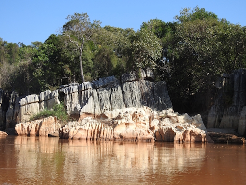
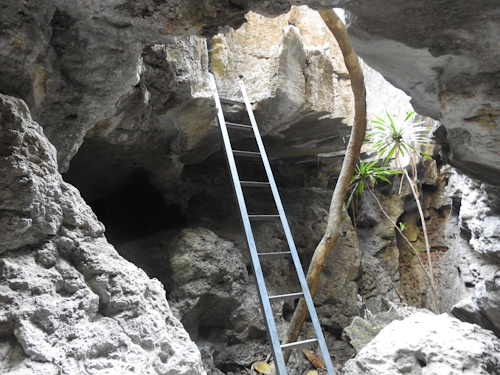
The park is bordered to the south by the Manambolo River; its Gorge “is a scenic attraction that adds to the intrinsic values of Bemaraha” according to the IUCN evaluation. We navigated it in two wooden canoes tied together, operated by a ‘poler’. The river, which cuts all the way through the limestone massif on a length of 370km to the sea, doesn’t run deep in the dry season. It has crocodiles, but the only wild animals we saw were birds. Mostly Diomorphic egrets, which nest here. We got out of the boat twice to look at caves, one where the guide enthusiastically pointed out dripstone (he obviously hadn’t been warned about my aversion against that natural feature), and the other where we saw a pretty nocturnal butterfly. Further up, high against the cliffs, the remains of Vazimba tombs can also be seen. The white skulls of the oldest Malagasy ancestors laying there even are visible to the naked eye.
Back on land, we walked to the entrance of the Petit Tsingy which lies next to the village. It does have a creative entrance sign (made out of pieces of tsingy) including a UNESCO logo, so I think we can count that as the plaque. Hiking in the Tsingy is a skill that takes a while to get used to – the rock tops are quite sharp, but most of the time you can hold on to them sideways. They will not break easily. You have to squeeze through narrow passages, where I’d say a person 5kg heavier than me already would really have trouble. Climbing is done via well-positioned steps, using handrails and ropes for support, and ladders. All these man-made additions were in good condition and really added to my confidence in getting around safely. In the end, I must say that I found the experience more ‘interesting’ than truly spectacular – the Petit Tsingy is just a tiny plot of Stone Forest, taking 1.5 hours at most.
The next day we departed at 6 a.m. for the Grand Tsingy. Its entrance lies 17km north of Bekopaka, so we started with another hour’s drive. This stretch of road is even worse than the others we’d been on so far, and we even got stuck on the way back (but my driver, my guide and the local park guide managed to dig us out). There’s a car park just outside the forest, from where the Grand Tsingy hikes start. We did the Andamozavaky Circuit.
The hike starts in the forest surrounding the Tsingy. It is home to lemurs, and we had good sightings of Decken's Sifaka (with a baby on the back) and Red-fronted Brown Lemur. After 1.5 km you reach the first ladder and that’s where the fun starts. I felt like a mountaineer, kitted up in a harness, clipping myself to the ropes that have been attached to the trickier parts, and climbing ladders to move from viewpoint to viewpoint. It is quite amazing how they have made these stony peaks accessible for viewing. After a couple of them though, you get the idea – it is what it is (googling 5 pictures of ‘Tsingy de Bemaraha’ will give you the best-known views) and comes without many surprises, although a blossoming flower at the bare rocks was a pretty sight.
I thoroughly enjoyed the whole expedition of getting there and being there, experiencing this part of Madagascar. It was one of the most adventurous WH visits I did so far. We managed to leave the area safely, this time with two armed soldiers in the back of ‘my’ 4WD as we led the convoy out.
Practicalities (June 2023):
- I reached the starting point of the expedition, the coastal city of Morondava, by a 1-hour domestic flight executed by Tsaradia from Tana (206 EUR). They only fly on Thursday and Sunday, and you have to book weeks ahead. Sometimes online booking via the official website may not work, then use Kiwi.com. I left again for Tana by Cotisse taxi-brousse, 12 EUR and 16+ hours.
- I had arranged the 4-day Tsingy transport (650 EUR) beforehand via R'jan Tsingy Expedition. Guesthouses and hotels in Morondava can link you with a local operator if you have not yet booked anything, the trip is regularly done in the dry season May-September.
- I booked the hotel in Bekopaka, the gateway town to Tsingy, myself: the Orchidee de Bemaraha, a dated but clean complex in a nice setting including a pool. They provide all meals as well, against a 50% higher cost than usual in Madagascar.
- The park entrance fee is 55,000 Ariary (12 EUR) per day. Plus the cost of a guided tour, depending on scope and group size about 165,000 Ariary (36 EUR). The boat guy and local guide expect a small tip as well. So bring lots of cash to the area (the hotel also only takes cash), I brought 2 million Ariary and used about 1.2 million!
Els - 2 July 2023
Comments
Els Slots 4 July 2023
I would not recommend it if you have an intense fear of heights. If it is just a little bit I think you would be fine.
Astraftis 4 July 2023
This sounds exceptional! Just a confirmation question: is all these ladders and scrambling compatible with some fear of heights, or is it really vertiginous as it seems?
Blog WHS Visits
WHS #845: Royal Hill of Ambohimanga
The Royal Hill of Ambohimanga is a fortified hill with great historical and symbolic value for the people of Madagascar. It is a wonderful site to visit as it is in good condition and has so many layers: the first unified Malagasy kingdom, the start of its interaction with the outside world just before colonial times, and a contemporary place of worship. I spent 3 hours there on a guided tour of the palace complex and a forest walk.
Although it lies only 20km away from the Madagascar capital Antananarivo, it will take the best part of an hour to get there by car. Leaving the busy city center is the hardest, after that, a fine drive along the rice paddies follows. Ambohimanga is one of many hills in this area. From viewpoints, you can also see the tomb of the King’s astrologer on the adjacent, slightly higher hill. Also, there are the remains of a palace in between these two hills. The astrologer’s hill is a popular place for local worship, the only way to get there is to walk up.
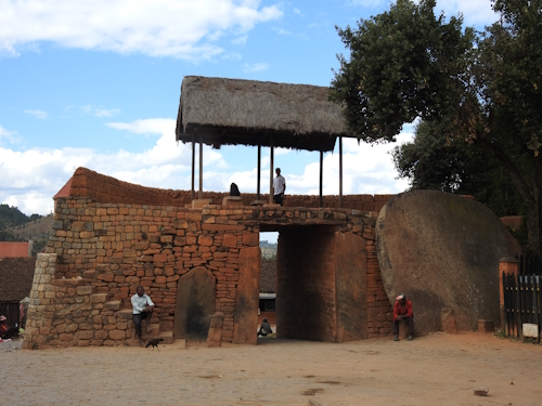
We started the visit to Ambohimanga after entering via the Royal Gate (photo 1). Local nobility started using this hilltop from the 15th century on, but most of what you now see dates from the early 19th century. The Malagasy royals were a promiscuous bunch, the guide told stories about the Queen that had all her lovers killed or the Prime Minister that ended up marrying three of the queens (the King had 12). The oldest remaining structure is the King’s palace, a traditional Malagasy wooden building, only somewhat larger than the regular houses but with interesting features inside. At the back, the tombs of the ancestors of the first King have been restored and what was left of the human remains has been re-interred, after they had been taken away to Antananarivo by the French in 1897.
The Queen’s palace next door, dating from 1871, has clear European influences. By that time the Malagasy were more aware of the outside world and got connected to foreign royalty. Gifts from Belgium, Spain and the British Queen Victoria have been preserved.
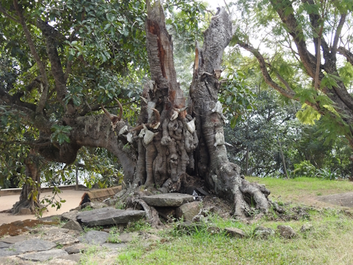
Although the colonial damage done here was brutal (the French wanted to break the Malagasy spirit), it has not destroyed the essence of the site and the residents are clearly proud of it. The slab of stone where the royal zebu were slaughtered is still in place, and yearly offerings continue as can be seen by the newish zebu horns in the collection nailed to the sacred fig tree (photo 2).
The 2-hour forest walk requires an additional entrance fee and a different guide, and it is not always on offer at the site reception. It did provide a deepening of my understanding of the site overall, so I would recommend taking it. The woodland lies within the larger gated enclosure of the Royal Hill and its large variety of plants and trees was maintained for practical and spiritual reasons. It is almost like a botanical garden and parts of it have been there for hundreds of years. Some plants are for medicinal use, others provide leaves for brewing tea, and strong wood species such as the Madagascar rosewood were used for the construction of buildings. Locals may still use the leaves and fruits, but not cut the trees.
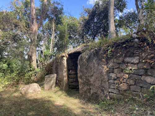
The dense forest also served as an extra layer of defense and along the trails you'll encounter old gates and the remains of a deep moat. There was a gate for the common people (photo 3), which was the main access road before the French made the current one via the royal gate. And there was a gate that was only used for carrying up deceased people. All gates have a large stone disc that could be rolled into place to close it. The gates were guarded by armed soldiers and also had hedges on top of the walls.
Finally, I’d like to recommend the little café with a panoramic terrace right at the site’s parking lot. Here they do a fine ‘Porc au Ravitoto’, which has a sauce made of crushed and cooked cassava leaves that tastes a bit like spicy spinach. The taboo on eating pork at the Royal Hill – reinstalled after the devastating cyclone of 2012 - seems not to be stringently adhered to!
Els - 25 June 2023
Blog WHS Visits
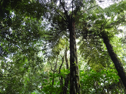
WHS #844: Rainforests of the Atsinanana
The Rainforests of the Atsinanana are the quintessential Malagasy WHS, as they comprise the last remaining patches of rainforest in Madagascar and are home to the iconic lemurs (of which 108 species have been discovered). Like the other reviewers before me, I choose to visit Ranomafana NP out of the 13 WH locations, as it is the easiest to reach. After 2 days of driving from the capital via Antsirabe along bare red soil and agricultural terraces, suddenly there they were: forests! Even in the dry season, it often rains here at night. More water is present at the river with a large waterfall next to the access road.
I stayed in Ranomafana village for one night; this way you can do the night walk after arrival and visit the diurnal creatures the next morning. You can allocate more time when you’re interested in a specialized subject like birds – the park has three sections, of which the main one holds most lemurs and the other two have their own qualities.
The night walk nowadays is executed along the road parallel to the park entrance - it is forbidden to enter the park borders after dark due to people getting lost / poaching (I heard both stories). I went with a local guide, for whom this side job was a welcome addition to his income as a banana farmer. He had sharp eyes, especially for chameleons, which became the stars of the walk. We saw many species, some tiny and others of a decent size. They did change colour when we looked more up and close, the trick is to then go quickly to look at it from the other side where the original colours are still present. Pictured above is the Blue-legged chameleon.
Lemurs also come in diurnal and nocturnal species. Our aim for the night was the Brown Mouse Lemur. The guides (there was another one present with a tourist couple in tow) use the help of rubbing banana smell to a tree branch – we saw one quickly, but the spot was used mainly by a rat that scared the lemur away. Later on, at a different place, we got eye-shine from the flashlights. Zooming in with my camera it proved indeed to be the mouse lemur, a small creature looking at us with two round eyes.
Around 7.30 the following morning we started the hike inside the park, after having bought a ticket at the reception (no sign of a WH plaque by the way). The ticket shows the Golden Bamboo Lemur, the flagship species of this park. With the guide (in all Malagasy national parks the use of a local guide is obligatory) we went on our way to see some flora but mostly lemurs of course. A tracker walked ahead to scout for these mammals. The main trail inside the park is fairly easy (a bit up and down) and paved with large stone blocks. Unfortunately, the lemurs usually do not come close to the path, although some of them are known to take the recently renovated bridge across the river in the early morning. The species that Ranomafana is especially known for, the various bamboo lemurs, take their breakfast in a patch of dense bamboo forest. When the tracker has found a lemur, you need to scramble up the hill and across tree trunks to get close enough to see them. The whole experience reminded me of Mgahinga NP TWHS in Uganda, where you go and look for Golden Monkeys in a similar bamboo forest.
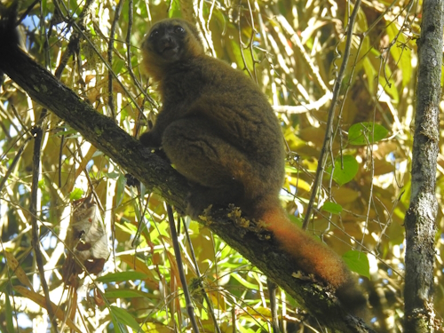
Fortunately, lemurs are more relaxed around humans and better resistant to noise than monkeys for example. Guides and tracker just shouted out to each other across the forest. And the lemurs kept nibbling away at their bamboo shoots with 6 photographing tourists underneath their tree. We eventually saw three species over the course of 3.5 hours: the critically endangered Greater Bamboo Lemur (looks like a large teddy bear), the also critically endangered Golden Bamboo Lemur (photo 3), and the less endangered (status: vulnerable) Red-bellied Lemur, which also lives in other parks but is not so commonly seen. These lemur species live as couples or families and are fairly quiet, so they’re not easy to spot by yourself.
Els - 18 June 2023
Blog WHS Visits
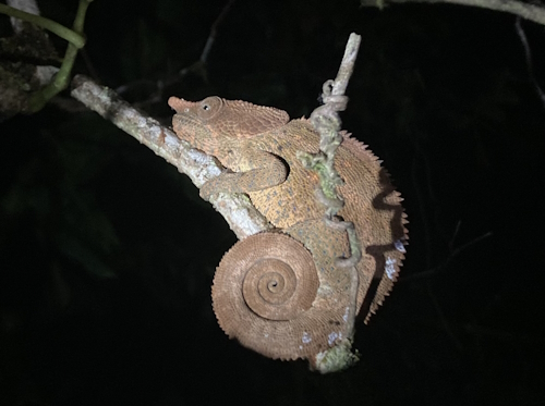
WHS #843: Pitons of Reunion
‘Completing’ France is a tough act, as its WHS include sites in four overseas territories scattered across the globe. The French Austral Lands are the hardest (9,000 EUR/28 days if you’re lucky to get a spot). Somewhat near in the Indian Ocean but much more accessible is Réunion, served by daily direct flights from Paris. This island is governed as an overseas department and its culture is very, very French. Réunion is blessed with its own WHS, the Pitons, Cirques and Remparts.
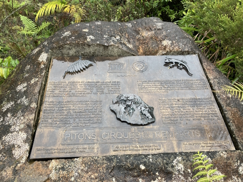
The WHS area geographically is a bit complicated, although it would be hard to never set foot in the core zone while spending a few days on the island. Generally, it covers the whole interior, but, it’s a WHS with an enclave, three enclaves even: they are the villages inside the cirques. And, the WHS is slightly larger than the national park. La Maison du Parc in La Plain des Palmistes, which acts as the park’s visitor center, has a very clear scale model of the island depicting the park’s borders and the WHS extras. I discovered the WHS plaque (photo 1) there as well: it is situated in a flowerbed to the right, about 10m before you enter the building. This WHS overall scores very well on the scale of the WHS commandments, with the wonderful bespoke plaque, the scale model showing core and buffer zones, and the park also being free to enter.
For my deep dive into the park, I choose the Cirque de Mafate. Measuring 14x9 km, it is shaped like a massive natural amphitheater, surrounded by steep ramparts: the result of a collapsed volcano. Due to its inaccessibility, it served as a natural shelter for runaway slaves from Madagascar, who arrived in the 18th and 19th centuries. Even nowadays some 700 people live inside the cirque, though there still is no road access and provisions have to be delivered by helicopter.
I went there on a guided day hike organized by BMR. It departed from the 4×4 car park on the Rivière des Galets in La Possession in the north of the island. This proved to be a popular starting point, and locals run a blossoming 4x4 business from here. The parking is the last place you can reach on your own (I got there by bus from St. Denis to Sacré Coeur + a 20-minute walk). Then you get into one of the 4wd trucks that will take you half an hour to the starting point of the trails. They drive on a rough unpaved track, which includes several river crossings. There and also later on during the hike we met lots of trail runners, a popular pastime here which culminates in the yearly Diagonale des Fous which fully crosses the rugged backbone of Reunion.
We were probably the guide’s tour group from hell: a Bulgarian guy who couldn’t speak French, a French woman who faired well until she started feeling lightheaded and had to lay down so we eventually had to abort the hike 30 minutes from the final viewpoint, and me – a slow climber, bad at descends too and taking even more time along the way to take pictures of birds. Honestly, I would have been just as happy if they had left me somewhere halfway, so I would have had more time to take in the scenery and take better photos of the plants and animals. The most notable sightings in the latter category were those of two tenrecs, a species that has spread to here from Madagascar and looks a bit like a mix of a hedgehog and a rat.
Hiking in Mafate is strenuous because of the technicality of the terrain, and having hiking poles really is a must (I had arranged some via the guide beforehand). At the start of the hike, you have to complete four river crossings, which can be done via stepping stones. I already failed at the first one and waded through the others as well. The water came to my knees, but the river flow wasn’t too strong. In every family/group I noticed at least one person struggling to make the crossings. Along the trail, three footbridges have been added to cross more dangerous ravines. Climbing is mostly done via stairs, which says enough about the steepness of the area. There are no easy hikes in Mafate, and the opportunities at the other two cirques are only slightly better.
Els - 11 June 2023
Blog Connections
Himalaya
Our Himalaya connection so far only had seven entries. None of them had any rationale, and the connection itself had no definition. As in my head it was time to travel to the Himalaya again (I still have so much ‘to do’ there), I decided to work on the upgrade of this connection for a bit and see whether there is potential for more Himalayan WHS in the future.
The definition
Everyone has an image in his/her mind of what and where the Himalaya are, but providing a solid definition isn’t that straightforward. It’s not one mountain range but a series of them, and it borders even more mountain ranges with overlapping values.
I eventually came up with:
WHS located in the Himalaya proper, the rugged arc between the Tibetan Plateau and the Ganges Plain. Including sites that are in its foothills or where the site lays claim to specific Himalayan features for its OUV.
This implicates:
- This scope excludes the Karakoram and Hindu Kush ranges, which it borders to the northwest (they could have their own connections in the future). Also, the Tibetan Plateau itself is not part of the Himalaya – so Qinghai Hoh Xil for example isn’t included. A helpful map can be found here.
- It includes sites in transition zones that 'self-identify' as Himalayan, as in deriving value from it by the landscape, the flow of a river, etc. This must be clear from the nomination dossier or the AB evaluation.
Current Himalayan WHS
To the 7 that we had already, I added:
- Mount Emei: “This is due to its transitional location at the edge of the Sichuan basin and the eastern Himalayan highlands”
- Manas Wildlife Sanctuary: “Manas is located at the foothills of the Eastern Himalayas”, “it is intricately linked to the Himalayas, including through the Manas River”
- Mountain Railways of India: “the Darjeeling Himalayan Railway located in the foothills of the Himalayas in West Bengal ... and the Kalka Shimla Railway located in the Himalayan foothills of Himachal Pradesh”
- Chitwan NP: “Nestled at the foot of the Himalayas”
- Sichuan Giant Panda Sanctuaries - Wolong: “a mixing zone between the subtropical flora of East Asia and the temperate flora of the Himalayan/ Qingzang Plateau” (AB ev)
Potential
On the Tentative Lists, we find these strong candidates:
- Cold Desert Cultural Landscape (India): includes parts of Ladakh and Spiti, and is “a trans-Himalayan marginal plateau land and edge region between the Greater Himalayas of India and the main Tibetan Plateau, which is an unparalleled location both physically and culturally.”
- Yalong Tibet (China): includes the middle reaches of the Yalong River, which "cuts through the Himalayas", and Himalayan geological structures.
- Scenic and historic area of Sacred Mountains and Lakes (China): Mt Kailash, “Nahumanni peak is the most typical ‘detachment’ of the Tibetan Plateau, which is identified as the key point for geologists to study the uplift of the Himalayas. It is also one of the largest concentrated areas of the Himalayan modern glaciers in the southwest of Tibet” “also one of the main corridors for the migration of rare wild animals such as Tibetan antelope and wild yak to the Tibetan Himalayas.”
- Neora Valley NP (India): “a compact patch of virgin forest, rich in biodiversity located in the Eastern Himalayas”
- Namdapha NP (India) at the edge of the Eastern Himalaya.
And we could also consider all TWHS of Nepal (which are all cultural by the way), notably Mustang and Lo Manthang. And all TWHS of Bhutan, notably the Bumdeling Wildlife Sanctuary and Jigme Dorji NP.
In our Missing exercises, we came up with Mount Kailash and Tashilunpo Monastery in Shigatse (both Tibet).
A study by the International Centre for Integrated Mountain Development (ICIMOD) in 2021 identified further potential. They used a wider scope, also including the Hindu Kush and extending the area from Afghanistan to Myanmar. But within our definition, they firstly suggest focusing on transboundary extensions: the Chinese part of the Everest region should be covered as well, as “Sagarmatha National Park (Nepal) encompasses part of the world’s highest mountain, a partial coverage following political borders rather than a conservation rationale”. The same rationale counts for Manas with an extension into Bhutan's Royal Manas NP.
As thematic ‘gaps’ they identified:
- The cold winter deserts;
- both the Eastern and the Western Himalayan Broadleaf and Conifer Forests;
- the Eastern Himalayan Alpine Shrub and Meadows (adjacent to the above-mentioned Eastern Himalayan Broadleaf and Conifer Forests);
- Rivers – “If any meaningful representations of untamed rivers of the world’s highest mountain ranges and their biodiversity are to remain, effective conservation approaches are needed now, including under the Convention”.
Which places in the Himalaya do you rate highly and would you put forward for a nomination?
Els - 4 June 2023
Comments
Dennis 6 June 2023
I don't know about Chitwan. You very definitely descend a long ways down from the mountains when driving there from Kathmandu. It's pretty much a lowland park, although you can see mountains in the distance.
Blog Index
Books
- Book: Natural Wonders of the World (30 July 2023)
- Book: Heaven on Earth (21 May 2023)
- Book: World Heritage Craze in China (26 March 2023)
- Possible Antarctic WHS (5 February 2023)
- Book: Cultural Heritage and Mass Atrocities (25 September 2022)
- Book: India: UNESCO World Heritage Sites (3 April 2022)
- Book: Great World Wonders (7 November 2021)
- Book: Chinese Heritage Sites and their Audiences (13 June 2021)
- Book: Coastal WHS (3 January 2021)
- Book: Atlas Obscura (10 February 2019)
- The Rebirth of Bodh Gaya (10 February 2018)
- Books: Modern African Architecture (18 February 2017)
- Books: Wonders of the World (28 November 2015)
- Book: Chasing 193 (8 July 2015)
- Book: The Heritage Universe (27 June 2015)
- Book: Japan's World Heritage Sites (26 October 2014)
Connections
- Himalaya (4 June 2023)
- One thousand visitors or fewer (23 April 2023)
- Canopy Walkways (2 April 2023)
- Invention of sweets and pastries (22 January 2023)
- Transnational WHS in the making (16 October 2022)
- Obelisks (21 August 2022)
- Threatened by Oil and Gas Exploration (7 August 2022)
- Byzantine (24 July 2022)
- Critically endangered fauna species (12 June 2022)
- Petrosomatoglyphs (1 May 2022)
- Fossil sites (17 April 2022)
- Cable cars (27 March 2022)
- Erotic Art (19 December 2021)
- Silk Road(s) (14 November 2021)
- Diluted by an Extension (31 October 2021)
- WHS and Beer (12 September 2021)
- Buildable in Lego (22 August 2021)
- WHS Hotspots (15 August 2021)
- WHS affected by Poaching (2 May 2021)
- Epic Subtitles (7 March 2021)
- No Road Access (28 February 2021)
- Expressionist Architecture (17 January 2021)
- Cold War (20 December 2020)
- Dependent Territories (29 November 2020)
- Mammal WHS (15 November 2020)
- Bird Migration WHS (24 May 2020)
- WHS in classic documentaries (12 April 2020)
- Unusual Entry Requirements (29 March 2020)
- WH Travel & Passports (1 December 2019)
- Railway WHS (1 September 2019)
- Why people die at WHS (21 April 2019)
- The Umayyads (17 March 2019)
- Historical Graffiti (3 March 2019)
- Viewable from another WHS (9 June 2018)
- One million or more (3 March 2018)
- WHS On Banknotes (16 December 2017)
- A Silk Roads overdose? (20 November 2016)
- A History of WHS in Danger (5 September 2015)
- WHS & World War I (19 October 2014)
Countries
- Top Tips for Madagascar (9 July 2023)
- Tips for Travelling to Western Turkey (14 May 2023)
- Tips for Travelling to Northern Brazil (8 January 2023)
- Tips for Travelling to Chad (20 November 2022)
- Top Tips for Eastern Canada (10 July 2022)
- Top Tips for Tunisia (29 May 2022)
- Top Tips for Northern Mexico (27 February 2022)
- Best Countries (23 January 2022)
- Tips for travelling to Kyrgyzstan (17 October 2021)
- Tips for travelling to Costa Rica (25 April 2021)
- Tips for travelling during a pandemic (14 March 2021)
- Tips for travelling to Iceland (20 September 2020)
- Tips for travelling to Colombia (16 February 2020)
- Tips for travelling to Russia (27 October 2019)
- Tips for travelling to Georgia (4 August 2018)
- Tips for travelling to the Gulf (2 May 2018)
- Value for money WH countries (24 March 2018)
- Tips for travelling to Namibia (3 February 2018)
- Tips for travelling to Ecuador (14 October 2017)
- Tips for travelling to Egypt (30 April 2017)
- Tips for Azerbaijan and Iran (3 June 2016)
- Tips for Rwanda, Congo and Uganda (30 January 2016)
- Tips for Travelling to Myanmar (31 October 2015)
- Mongolia's Tentative List (28 February 2015)
- How to visit the (T)WHS of Sudan (22 November 2014)
Exhibitions
- Rietveld Bike Tour (26 November 2017)
- Looking for the Golden Rhino (4 December 2016)
- Vestfold Ship Burials (18 June 2016)
- Rome. Emperor Constantine’s dream. (22 November 2015)
- Carthage (8 March 2015)
TWHS Visits
- WHC 2023: Kuldīga (6 August 2023)
- Gordion (7 May 2023)
- Íznik (30 April 2023)
- Niah Caves (19 March 2023)
- Banteay Chhmar (19 February 2023)
- Via Appia (30 October 2022)
- Valentia's Transatlantic Cable Ensemble (23 October 2022)
- Civita di Bagnoregio (9 October 2022)
- Zagori & Pindos (11 September 2022)
- Talayotic Minorca (21 November 2021)
- Kyrgyz Silk Roads: Uzgen (10 October 2021)
- Historic Center of Parma (29 August 2021)
- Bachkovo Monastery (18 July 2021)
- Mosaics of Philippopolis (11 July 2021)
- Prince-Bishops' Palace in Liège (20 June 2021)
- Lower German Limes: Berg en Dal Aqueduct (30 May 2021)
- Corcovado NP (11 April 2021)
- Guayabo National Monument (24 March 2021)
- San José (21 March 2021)
- Buenos Aires 1880-1920 (21 February 2021)
- The Egyptian Museum (14 February 2021)
- The Meuse Citadel of Namur (7 February 2021)
- The Neanderthal fossil sites of Wallonia (24 January 2021)
- Plantations in West Curacao (13 December 2020)
- Unreviewed TWHS: Hirkan Forests (22 November 2020)
- Sanxingdui in 2007 (8 November 2020)
- Archipelago of La Maddalena (25 October 2020)
- Bouches de Bonifacio (18 October 2020)
- Nice (4 October 2020)
- Mediterranean Alps (27 September 2020)
- Icelandic Turf House Tradition (13 September 2020)
- Mývatn and Laxá (30 August 2020)
- Fjallabak (23 August 2020)
- Old Wastewater Treatment Plant (16 August 2020)
- Mértola (5 August 2020)
- Vila Viçosa (2 August 2020)
- Works of Álvaro Siza (19 July 2020)
- Great Spas: Bad Ems (28 June 2020)
- ShUM city of Worms (21 June 2020)
- Chapultepec (7 June 2020)
- Frederiksoord-Wilhelminaoord (17 May 2020)
- Tuol Sleng Genocide Museum (3 May 2020)
- Unreviewed TWHS: Lalish Temple (26 April 2020)
- Unreviewed TWHS: Bahoutdin Complex (5 April 2020)
- New Dutch Waterline (22 March 2020)
- WHC 2021: The Slate Landscape (15 March 2020)
- Unreviewed TWHS: Tansen (8 March 2020)
- Sarlat at Night (1 March 2020)
- Salt Town of Nemocón (5 January 2020)
- Virgilio Barco Library (29 December 2019)
- Irkutsk (20 October 2019)
- Staigue Stone Fort (25 August 2019)
- The Royal Sites of Ireland: Cashel (18 August 2019)
- Hospital of Our Lady with the Rose (11 August 2019)
- WHC 2019: Krzemionki (30 June 2019)
- Chobe (2 June 2019)
- WHC 2021: Sarnath (5 May 2019)
- Olive Grove Landscape of Lucena (14 April 2019)
- Lower German Limes: Xanten (31 March 2019)
- Harran and Sanliurfa (24 March 2019)
- Padova Urbs Picta (10 March 2019)
- WHC 2019: Paraty Culture and Biodiversity (24 February 2019)
- WHC 2019: Walled City of Jaipur (17 February 2019)
- Ancient Quanzhou (26 January 2019)
- Yen Tu: Vinh Nghiem Pagoda (5 January 2019)
- Roman heritage of Nîmes (1 December 2018)
- Raoudha Nilometer (24 November 2018)
- WHC 2019: Danube Limes - Arrianis (31 October 2018)
- Uplistsikhe Cave Town (21 July 2018)
- Tbilisi Historic District (14 July 2018)
- David Gareji Monasteries (23 June 2018)
- Fortress of Ananuri (16 June 2018)
- Gdansk - Town of Memory and Freedom (2 June 2018)
- WHC 2018: Žatec, Town of Hops (12 May 2018)
- Ore Mountains (5 May 2018)
- Dubai Creek (28 April 2018)
- Sharjah: the Gate to Trucial States (18 April 2018)
- Forts of Rostaq and al-Hazm (4 April 2018)
- Kuwait Towers (31 March 2017)
- Teylers (17 March 2018)
- WHC 2019: Plečnik in Ljubljana (17 February 2018)
- Etosha Pan (10 January 2018)
- Benguela Current (5 January 2018)
- Fish River Canyon (1 January 2018)
- Lechner's pre-modern architecture (9 December 2017)
- WHC 2018: Chaîne des Puys (18 November 2017)
- Hoge Kempen Transition Landscape (21 October 2017)
- Mathildenhöhe (19 August 2017)
- Mid-Atlantic Ridge (6 July 2017)
- Ptolemaic Temples (21 April 2017)
- WHC 2017: Dilmun Burial Mounds (11 February 2017)
- Palau and the Yapese Stone Money (7 January 2017)
- Tet el Bad (Stone Coffin) (1 January 2017)
- Hanyangdoseong (29 December 2016)
- Zadar - Romans and Venetians (12 November 2016)
- Nelson Mandela Legacy Sites (19 October 2016)
- Ngwenya Mines (12 October 2016)
- 1940's - 1950's Architecture of Minsk (7 September 2016)
- 20th Century Ivrea (13 August 2016)
- Waterloo (30 July 2016)
- Agricultural Pauper Colonies (9 July 2016)
- Masouleh (25 May 2016)
- Sheki, the Khan's Palace (2 May 2016)
- Temple of Fire (24 April 2016)
- Fortress Town of Palmanova (12 March 2016)
- WHC 2016: Rediscovering Dosan Seowon (13 February 2016)
- WHC 2016 – Corbusier’s Villa Savoye (7 February 2016)
- Mgahinga – Where Gold Meets Silver (9 January 2016)
- Rwandan Genocide Memorial Sites (29 December 2015)
- WHC 2016: Cetinje (5 December 2015)
- WHC 2016: Ani Cultural Landscape (13 November 2015)
- Sonian Forest’s Beech Cathedral (7 November 2015)
- Ancient cities of Upper Myanmar (24 October 2015)
- Bagan Archaeological Zone (17 October 2015)
- Konbaung Wooden Monasteries (9 October 2015)
- WHC 2015: Christiansfeld (20 June 2015)
- The Mystery of Kokino (14 June 2015)
- Amphitheatre of Durres (3 June 2015)
- WHC 2015: Champagne (14 May 2015)
- WHC 2015: Palermo, Cefalù & Monreale (9 May 2015)
- Two TWHS in Antwerp (6 April 2015)
- Five Dzongs of Bhutan (14 March 2015)
- Granada and its natural environment (20 February 2015)
- Volcan Masaya - Exciting or not? (14 February 2015)
- WHC 2015: Singapore Botanic Gardens (20 December 2014)
- Old Dongola (1 December 2014)
- Great Spas of Europe: the original Spa (15 November 2014)
- WHC 2015: Hagi Castle Town (9 November 2014)
Travel in general
- My experience travelling ultra-light (20 March 2022)
WH Travellers
- The Value of a TWHS (16 July 2023)
- The 9 WHS Commandments (5 March 2023)
- Nine things I learned in my first year of full-time travel (1 January 2023)
- Revisit needed (27 November 2022)
- Shandos ... planning a WH trip to South America (2 October 2022)
- Michael Ayers ... cycling to over 300 WHS (5 June 2022)
- WH Travel Focus (10 April 2022)
- The quest to 1100 visited WHS in 2030 (2 January 2021)
- Wojciech and Thomas ... In Iraq (28 November 2021)
- Zos M. ... Completing China (24 October 2021)
WHS Visits
- WHS #846: Tsingy de Bemaraha (2 July 2023)
- WHS #845: Royal Hill of Ambohimanga (25 June 2023)
- WHS #844: Rainforests of the Atsinanana (18 June 2023)
- WHS #843: Pitons of Reunion (11 June 2023)
- Kraków revisited (9 April 2023)
- WHS #833: Gunung Mulu (12 March 2023)
- WHS #831: Kui Buri NP (26 February 2023)
- WHS #827: Sambor Prei Kuk (12 February 2023)
- WHS #825: Mazagan (29 January 2023)
- WHS #813: Fernando de Noronha (18 December 2022)
- WHS #812: São Luis (11 December 2022)
- WHS #811: Central Amazon (4 December 2022)
- WHS #810: Ounianga Lakes (13 November 2022)
- WHS #809: Ennedi (6 November 2022)
- WHS #807: Island of Patmos (18 September 2022)
- WHS #804: Mount Athos (4 September 2022)
- Skellig Michael 2022 (14 August 2022)
- WHS #800: Red Bay (3 July 2022)
- WHS #798: Mistaken Point (26 June 2022)
- WHS #797: Gros Morne NP (19 June 2022)
- WHS #789: Kairouan (22 May 2022)
- WHS #786: Carthage (15 May 2022)
- WHS #783: Lake District (24 April 2022)
- WHS #780: Quirigua (13 March 2022)
- WHS #778: Joya de Ceren (6 March 2022)
- WHS #774: Sierra de San Francisco (20 February 2022)
- WHS #773: El Vizcaíno (13 February 2022)
- WHS #771: EPGDABR (6 February 2022)
- WHS #766: Otumba (30 January 2022)
- WHS #765: Paquimé (16 January 2022)
- Luxembourg revisited (9 January 2022)
- WHS #764: Serra de Tramuntana (5 December 2021)
- WHS #763: Sulaiman-Too (3 October 2021)
- WHS #762: Western Tien-Shan (26 September 2021)
- Silk Roads: Zhetysu region (19 September 2021)
- WHS #761: Bologna (5 September 2021)
- WHS #760: Cordouan Lighthouse (8 August 2021)
- WHS #747: The Prosecco Hills (25 July 2021)
- WHS #746: Kazanlak (4 July 2021)
- WHS #745: Pirin National Park (27 June 2021)
- Wadden Sea: Schiermonnikoog (16 May 2021)
- WHS #744: Guanacaste (18 April 2021)
- WHS #743: Stone Spheres (4 April 2021)
- WHS #742: Talamanca Range (28 March 2021)
- Wadden Sea: Texel (10 January 2020)
- WHS #741: Willemstad (6 December 2020)
- WHS #740: Su Nuraxi di Barumini (1 November 2020)
- WHS #739: Gulf of Porto (11 October 2020)
- WHS #738: Surtsey (6 September 2020)
- WHS #737: Thingvellir (2 September 2020)
- WHS #736: Vatnajökull (26 August 2020)
- WHS #735: Kladruby nad Labem (9 August 2020)
- WHS #734: Bom Jesus do Monte (26 July 2020)
- WHS #733: Mafra (12 July 2020)
- Cologne revisited (14 June 2020)
- Aachen revisited (31 May 2020)
- WHS #732: Vézère Valley (23 February 2020)
- WHS #731: Cartagena de Indias (9 February 2020)
- WHS #730: Mompox (2 February 2020)
- WHS #729: Coffee Cultural Landscape (26 January 2020)
- WHS #728: Tierradentro (19 January 2020)
- WHS #727: San Agustín (12 January 2020)
- WHS #726: St. George, Bermuda (24 November 2019)
- WHS #725: Augsburg (17 November 2019)
- Val di Noto - Catania (10 November 2019)
- WHS #724: Mount Etna (3 November 2019)
- WHS #723: Lake Baikal (13 October 2019)
- WHS #722: Sviyazhsk (6 October 2019)
- WHS #721: Bolgar (29 September 2019)
- WHS #720: Kazan Kremlin (22 September 2019)
- WHS #719: Trinity Sergius Lavra (15 September 2019)
- WHS #718: Church of the Ascension (8 september 2019)
- WHS #706: Tokaj Wine Region (28 juli 2019)
- WHS #705: Hortobagy NP (21 July 2019)
- WHS #704: Hollókő (14 July 2019)
- WHS #703: Bialowieza Forest (23 June 2019)
- WHS #702: Zamość (16 June 2019)
- WHS #701: Victoria Falls (9 June 2019)
- WHS #700: Okavango Delta (28 May 2019)
- WHS #699: Tsodilo (19 May 2019)
- WHS #698: Naumburg Cathedral (28 April 2019)
- WHS #697: Medina Azahara (7 April 2019)
- WHS #696: Fujian Tulou (2 February 2019)
- WHS #695: Kulangsu (19 January 2019)
- WHS #694: Hani Rice Terraces (16 January 2019)
- WHS #693: Chengjiang Fossil Site (12 January 2019)
- WHS #692: Zuojiang Huashan (9 January 2019)
- WHS #691: Ho Citadel (2 January 2019)
- WHS #690: Trang An (29 December 2018)
- Hôtel Solvay (15 December 2018)
- WHS #689: Cave of Pont d'Arc (8 December 2018)
- WHS #688: Wadi al-Hitan (17 November 2018)
- WHS #687: Historic Cairo (10 November 2018)
- WHS #686: the Pyramid Fields (3 November 2018)
- WHS #685: Valtice (27 October 2018)
- WHS #684: Kromeriz (24 October 2018)
- WHS #683: Litomysl Castle (21 October 2018)
- Athens Acropolis revisited (17 October 2018)
- WHS #682: Daphni Monastery (13 October 2018)
- WHS #681: Meteora (9 October 2018)
- WHS #680: Philippi (6 October 2018)
- WHS #679: Bursa (29 September 2018)
- Istanbul revisited (26 September 2018)
- WHS #678: Nessebar (22 September 2018)
- WHS #677: Srebarna (19 September 2018)
- WHS #676: Churches of Ivanovo (15 September 2018)
- WHS #675: Tomb of Sveshtari (12 September 2018)
- WHS #674: Madara Rider (8 September 2018)
- WHS #673: Geirangerfjord (26 August 2018)
- WHS #672: Alta Rock Art (18 August 2018)
- WHS #671: Visby (28 July 2018)
- WHS #664: Gelati Monastery (7 July 2018)
- WHS #665: Qalhat (1 July 2018)
- WHS #663: Upper Svaneti (27 June 2018)
- WHS #662: Mtskheta (20 June 2018)
- WHS #661: Malbork Castle (26 May 2018)
- WHS #660: Torun (19 May 2018)
- WHS #659: Cultural Sites of Al Ain (25 April 2018)
- WHS #658: Land of Frankincense (21 April 2018)
- WHS #657: Bat and Al-Ayn (14 April 2018)
- WHS #656: Bahla Fort (11 April 2018)
- WHS #655: Aflaj of Oman (7 April 2018)
- WHS #654: Ibiza (25 February 2018)
- WHS #653: Robben Island (22 January 2018)
- WHS #652: Cape Floral Region (19 January 2018)
- WHS #651: Twyfelfontein (15 January 2018)
- WHS #650: Namib Sand Sea (12 January 2018)
- WHS #649: Pécs Necropolis (3 December 2017)
- WHS #648: Saint-Savin sur Gartempe (11 November 2017)
- WHS #647: Bourges Cathedral (4 November 2017)
- WHS #646: Galapagos Islands (7 October 2017)
- WHS #645: Quito (30 September 2017)
- WHS #644: Sangay NP (26 September 2017)
- Ingapirca (22 September 2017)
- WHS #643: Cuenca (19 September 2017)
- WHS #642: Antequera Dolmens (16 September 2017)
- WHS #641: Tetouan (13 September 2017)
- WHS #640: Gorham's Cave (10 September 2017)
- WHS #639: Neolithic Orkney (27 August 2017)
- WHS #638: Ice Age Art Caves (13 August 2017)
- WHS #637: Røros (30 July 2017)
- WHS #635: Pico Island (15 July 2017)
- WHS #634: Angra do Heroismo (1 July 2017)
- Wooden tserkva of Zhovkva (10 June 2017)
- WHS #633: L'viv (4 June 2017)
- WHS #632: Telc (20 May 2017)
- WHS #631: Cesky Krumlov (13 May 2017)
- WHS #630: Holasovice (6 May 2017)
- WHS #629: Nubian monuments (26 April 2017)
- WHS #628: Ancient Thebes (16 April 2017)
- Paris revisited (27 March 2017)
- WHS #627: Salins-les-Bains (11 March 2017)
- WHS #626: Beaune (Burgundy) (4 March 2017)
- WHS #625: Par force hunting landscape (4 February 2017)
- WHS #624: Royal Joseon Tombs (21 January 2017)
- WHS #623: Baekje sites in Gongju (14 January 2017)
- WHS #622: Namhansanseong (11 January 2017)
- WHS #621: Rock Islands (4 January 2017)
- Westminster Abbey (10 December 2016)
- WHS #620: Plitvice Lakes (5 November 2016)
- WHS #619: Vredefort Dome (29 October 2016)
- WHS #618: Drakensberg (22 October 2016)
- WHS #617: iSimangaliso Wetland (15 October 2016)
- WHS #616: Mapungubwe (8 October 2016)
- WHS #615: Makapan Fossil Hominid Site (3 October 2016)
- WHS #614: Nesvizh (17 Sept 2016)
- WHS #613: Mir Castle (10 September 2016)
- WHS #612: Kernavė (3 september 2016)
- WHS #611: Curonian Spit (26 August 2016)
- Palazzina di Stupinigi (20 August 2016)
- WHS #610: Piedmont Vineyards (6 August 2016)
- WHS #606: Reichenau (2 July 2016)
- WHS #605: Swiss Alps (25 June 2016)
- WHS #604: Rjukan / Notodden (10 June 2016)
- WHS #603: Golestan Palace (28 May 2016)
- WHS #602: Soltaniyeh (21 May 2016)
- WHS #601: Takht-e Soleyman (18 May 2016)
- WHS #600: Armenian Monastic Ensembles (14 May 2016)
- WHS #599: Tabriz Bazaar (11 May 2016)
- WHS #598: Safi al-Din Ensemble (8 May 2016)
- WHS #597: Gobustan Rock Art (5 May 2016)
- WHS #596: Walled City of Baku (29 April 2016)
- A Rainy Day in Oporto (16 April 2016)
- WHS #595: Rock Art of the Coa Valley (2 April 2016)
- WHS #594: Santiago de Compostela (26 March 2016)
- Another piece of the Longobard puzzle (5 March 2016)
- Venice in one day (27 February 2016)
- WHS #593: Aquileia (21 February 2016)
- WHS #592: Kasubi Tombs (24 January 2016)
- WHS #591: Rwenzori Mountains (20 January 2016)
- WHS #590: Bwindi (15 January 2016)
- WHS #589: Virunga! (4 January 2016)
- A second look at Edinburgh (19 December 2015)
- WHS #588: Forth Bridge (13 December 2015)
- WHS #587: Pyu City of Halin (3 October 2015)
- WHS #586: Wachau (19 September 2015)
- WHS #585: Neusiedlersee (13 September 2015)
- WHS #584: Gammelstad (19 August 2015)
- WHS #583: Laponia (15 August 2015)
- Searching for the Wadden Sea (8 August 2015)
- WHS #582: Wooden Tserkvas (1 August 2015)
- WHS #581: Malopolska Churches (25 July 2015)
- WHS #580: Auschwitz Birkenau (19 July 2015)
- WHS #570: Medieval Monuments in Kosovo (10 June 2015)
- WHS #569: Ohrid Region (6 June 2015)
- WHS #568: Berat and Gjirokaster (30 May 2015)
- WHS #567: Butrint (27 May 2015)
- WHS #566: Corfu Old Town (24 May 2015)
- WHS #565: Vézelay (20 May 2015)
- WHS #564: Cistercian Abbey of Fontenay (17 May 2015)
- Remembering the Kathmandu Valley (3 May 2015)
- Florence in-depth (27 April 2015)
- WHS #563: Medici Villas and Gardens (21 April 2015)
- WHS #562: A Mining Landscape (25 March 2015)
- WHS #561: León Cathedral (6 February 2015)
- WHS #560: Ruins of León Viejo (31 January 2015)
- WHS #559: Portobelo (24 January 2015)
- WHS #558: Panamá (18 January 2015)
- WHS #557: San Cristobal de La Laguna (10 January 2015)
- WHS #556: Teide National Park (3 January 2015)
- WHS #555: Gomera's Garajonay (29 December 2014)
- WHS #554: Magnificent Meroë (13 december 2014)
- WHS #553: Gebel Barkal (7 December 2014)
- WHS #552: The Two Faces of Corvey (2 November 2014)
WHS website
- The WHS Commandments pt.2 (23 July 2023)
- The 10,000th Review (28 May 2023)
- Aspiring TWHS (16 April 2023)
- WHS In the News (15 January 2023)
- 2022 - A Year in Review(s) (25 December 2022)
- Country pages (28 August 2022)
- Perfect Inscriptions (31 July 2022)
- WHS tracking apps (17 July 2022)
- Spring Cleaning (8 May 2022)
- 2021 - A Year in Review(s) (26 December 2021)
- Resources about WHS (12 December 2021)
- 10 Bits of Trivia about the WHS of 2020/2021 (1 August 2021)
- The Global Strategy in 2021 (6 June 2021)
- TWHS project: the wrap-up (23 May 2021)
- WHS Plaques and Certificates (9 May 2021)
- Pimping the TWHS pages (31 January 2021)
- 2020 - A Year in Review(s) (27 December 2020)
- Looking ahead to 2021 (5 July 2020)
- Taking Travel Risks (10 May 2020)
- Remembering Iain Jackson (18 April 2020)
- 2019 - A Year in Review(s) (22 December 2019)
- A free course in World Heritage (8 December 2019)
- WH Travellers meeting 2019 (4 August 2019)
- 10 Bits of Trivia about the WHS of 2019 (7 July 2019)
- Debunking travel blog myths (12 May 2019)
- Leftovers (22 December 2018)
- Official websites of WHS (11 August 2018)
- An improved website (27 January 2018)
- 2017 - A Year in Review(s) (23 December 2017)
- Favourite entrance tickets to WHS (28 October 2017)
- Completing Europe (27 January 2017)
- WH Trip Planning in 5 steps (21 December 2016)
- WH Travellers meeting in Vilnius (31 August 2016)
- 10 Bits of Trivia about the WHS of 2016 (23 July 2016)
- WHS Top 200: The Results (9 April 2016)
- What counts as a visit? (19 March 2016)
- One of our Missing: Shwedagon Pagoda (27 September 2015)
- WH Travellers meeting in Rotterdam (26 August 2015)
- A 17-Year Journey (12 October 2014)